|
|
Thursday, January 23, 2025
|
|


|
| MAIN | HOW TO REACH | HOTELS | CONTACTS | |
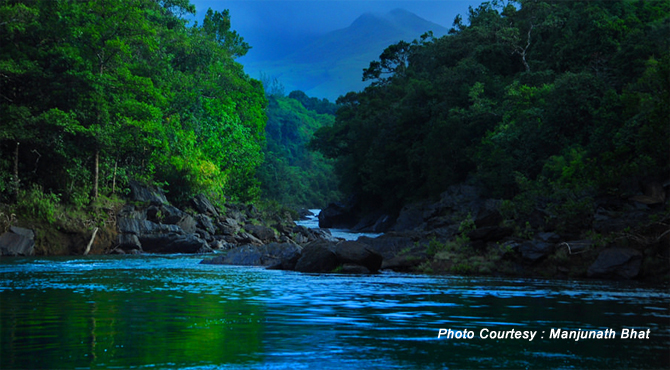
Lying on the sounthern ridge of Karnataka State's border, Kudremukh or Kuduremukha is a hill range as well as the name of a mountain peak. The peak is located in the mountain range of Chikmagalur District. Blessed with rich biodiversity, Kudremukh is also famous for the deposits of iron ore and feeds to the Kudremukh Iron Ore Company Limited (KIOCL). Kudremukh means 'horse's face' in Kannada language. The one side of the peak resembes the face of a horse and hence the name. With five sacred ponds located near the town - Amba Teertha, Naga Teertha, Vasishtha Teertha, Rudra Teertha and Varaha Teertha – Kudremukh serves as the pilgrimage for Hindus. The three famous rivers- Bhadra River, Nethravati River and Tunga River are originate in the region. A landscape, designed entirely by rain, Kudremukh mountain range is wide and connected with each other, offering a variety of trailing options for enthusiasts. The trails through dense forests, grassy slopes and tropical riverbeds attracts a younger crowd who are interested in trekking and exploring forests. One can view rare orchids and certain species and enjoy the fresh mountain air as you explore the grassland. The best time to visit Kudremukh is between the months of October to February. The region in and around Kudremukh receives about 7000 mm of rainfall per annum. Things to see and Do Kudremukh Peak Kudremukh, occupies the central region of the ghats with many tall peaks. The highest of them touching 6,214 ft. It is this peak whose name means 'horse face' falls before the town. It is Karnataka's 3rd highest peak after Mullayangiri and Bababudangiri. On a very clear day, one can see beautiful and mesmerising Arabian Sea. The peak is generally closed to visitors in the forest fire season. Lakya Dam Situated just outside Kudremukh, it was built by Kudremukh Iron Ore Company Ltd (KIOCL) to deposit the red sludge from its mines over river Lakya a tributary of Bhadra river. It is a great place for a evening walk across the dam. Since, the dam is sited in a protected forest region inside the Kudremukh National Park, permission from forest department is required to visit the Dam area. Tourists visiting Lakya Dam can also visit the Kudremukh National Park. Though there is a guard to post all warnings, under no circumstances climb over the rocks because the sludge is dangerous. Timings: Weekdays 4.30 am to 6.30pm, Sundays 9.30 am to 6.30 pm. Kudremukh National Park The park named after the peak is 10 km from the town. It extends over three districts, Dakshin Kannada (South Kanara), Chickmaglur and parts of Udupi and stretches between Narasimha Parvatha (in Sringeri Taluk) in the north to the Jamalabad Fort (in Belthangady Taluk) in the south. The park is divided into four ranges Kudremukh, Kerekatte, Kalsa, Shimoga. The park with an area of 600.32 sq.kms is 1,894.3 meters above sea level and is rich in iron ore deposits. The largest iron ore mining company, Kudremukh Iron Ore Company (KIOCL) is situated within the park area. The park is cool and salubrious round the year, but during monsoon from June to September, there is heavy rainfall. There is a wide variety of flora and fauna in the park. It is surrounded by Coffee and Tea plantations on the northern and eastern boundaries. The best time to visit the park is immediately after the monsoon ie, October to May when the forests are lush green. To watch the wild animals best time to visit is between December and February. |
|
NEARBY ATTRACTIONS |
||||||||||||||||||||||
|
||||||||||||||||||||||
|
|||||||||||||||||||||||||||||||||||
EXPLORE PLACES BY STATES |
||||||||||||||||||||||||||||||||||||||
|
||||||||||||||||||||||||||||||||||||||