|
|
Friday, July 24, 2026
|
|


|
| MAIN | HOW TO REACH | HOTELS | CONTACTS | |
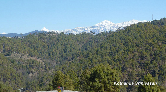
It is situated at the foothils of the snow clad Panchchuli peaks separate it from the Johar Valley. Dharchula was an ancient trading town on the Trans-Himalayan trade routes since medieval times. The name 'Dharchula' is derived from the words 'Dhar' and 'Chula'; Dhar means peak and chula means stove in Hindi. The name was given to Dharchula as the mountains are like stove here. Dharchula is situated on the banks of River Kali, which forms a natural boundary between India and Nepal. Named after Goddess Kali (incarnation of Goddess Durga), the river Kali is originates from the Greater Himalayas at Kalapaani that has an altitude of 3,600 metres above sea level. Dharchula is mainly inhabited by the people of Rung tribe and Kumaoni and Dotiyali languages are spoken by them. The best time to visit Dharchula is between the months of March and June and between September and December. During Summers, it is hot as in plains, whereas the winters are very cold with snowfall. The place looks more beautiful during these period with snow capped hills. The picturesque area offers a variety of flora and fauna to see. Trees of oak, pine, apple and deodar are common. Wild animals like leopard, bear, fox, monkeys and deers are found in this region. Apart from these, domestic animals like horses, mules and sheep are also found here. The innumerable treks of the mighty Himalayas, rafting down the roaring river Kali, innumerable waterfalls, beautiful meadows, valleys picturesque hills etc make Dharchula a perfect vacation. At Dharchula inner line permit a mandatory document is required as India shares its border with China. Places to visit Narayan Ashram The Narayan Ashram is a spiritual centre, situated just 14 kms away from Tawaghat. Established in 1936 by Shri Narayan Swami, it is situated at an elevation of 2,734 metres above sea level. The Ashram can accommodate up to 40 people at any given time. Visitors can enjoy several spiritual activities like meditation, satsang, rituals, and many more. This ashram is closed in winters due to heavy snowfall in the valley. Tourists can reach the spiritual centre from Ogla, Jauljibi and Tawaghat which are in close proximity. Jauljibi This place is situated at the confluences of Kali and Gori Rivers. It is situated about 23 kms from Dharachula and 61 kms. from Dharchula. During autumn season, an annual trade fair is held which is an indication of the cultural and commercial prosperity of the region. The place is thronged by the natives and the Nepalese inhabitants to sell horses, ghee foreign goods and take back food grains etc. Chipla Kedar It is situated 34 kms from Tawaghat. According to the belief of locals, the meadow of Chipla Kot, which is situated between the Dhauli and Gori rivers, is considered the abode of all deities of the people of the Kumaon region. A trekker's paradise, it offers picturesque view of Himalayas. The other main attraction here is Chipla Kedar Lake. As per hindu mythology, it was known as 'Gupt Kailash' (hidden kailash) in past. Every two years, a fair is organised in the 'Saptami' of 'Bhadon' month of the Hindu calendar and people from 42 villages gather here to worship, which continues for 5 days. The yatra started from Syankuri village, Dharchula subdivision, and at Chipla Kedar Lake, devotees take a holy dip. Kali River Named after Goddess Kali (incarnation of Goddess Durga), the river Kali is a holy river which originates from the Greater Himalayas at Kalapaani that has an altitude of 3,600 metres above sea level. Chirkila Dam One of the popular picnic locations in the region, the Chirkila dam is constructed on the Kali River. It is situated 20 km ahead of Dharchula town. Askot Sanctuary This sanctuary was set up primarily for to protect the musk deer (Moschus leucogaster) and its habitat. Established in 1986, the sanctuary covers an area about 599.93km². Set amidst snow-capped peaks, glaciers, ridges, beautiful valleys and pristine forests in the Indo-Nepal border, the sanctuary is really a haven for wildlife, birds and butterflies. The two main rivers Dhauli and Ikli rivers originate from here and and Gori Ganga flows amidst the unending stretches of pine, shisham, oak and sal trees through the sanctuary. Perched on the ridge of Kumaon Himalayas, at an elevation of 5,412 feet makes Askot sanctuary is a stunningly scenic sanctuary. It offers magnificient view of the famous peaks such as Panchchuli, Neodhura, Naukana, Chhiplakot and Najirikot. read more... |
|
NEARBY ATTRACTIONS |
|||||||||||||||||||||||||||||||||||||
|
|||||||||||||||||||||||||||||||||||||
|
|||||||||||||||||||||||||||||||||||
EXPLORE PLACES BY STATES |
||||||||||||||||||||||||||||||||||||||
|
||||||||||||||||||||||||||||||||||||||